Monitoring and Research

Monitoring and Research

Our ecological and land care team work to assist organisations to plan and maintain the natural quality of terrestrial and wetland ecosystems so that they can continue to function, and environmental values can be protected.

SERCUL’s ecological monitoring and research team are focused on achieving client and ecosystem needs by using a collaborative and practical approach.

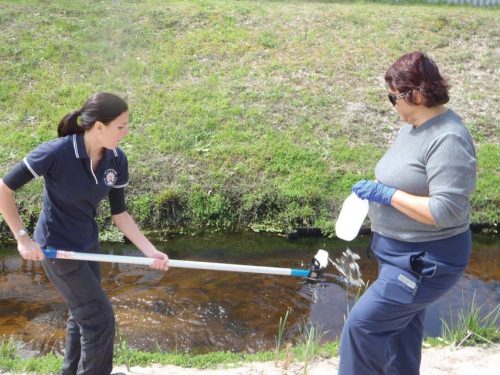
We ensure we have relevant permits to conduct our work. This includes providing a range of services including advice on site and parameter selection, sampling program design, field observations, photographs, data management, reporting and recommendations on management. Our goal is to provide the type of information relevant to our clients and in a format that can be used by the client to implement on-ground actions.

We can conduct the following programs.

It is also possible to combine these programs. For example, by combining water quality assessments with freshwater macroinvertebrate and riparian zone floristic assessments will assist an organisation to better understand their wetlands and therefore better plan whole ecosystem protection. 

icon box image

Water Quality

Monitoring and assessments

icon box image

Sediment and Soil

Monitoring and assessments

icon box image

Freshwater Macroinvertebrate

Monitoring and assessments

icon box image

Terrestrial Invertebrate

Monitoring and assessments

icon box image

Blue Carbon and Floristic Surveys

Monitoring and Assessments

icon box image

Integrated Mosquito Management

Education and Research

Wetland Monitoring and Assessments

Australia’s climate is changing.
Wetlands and the flora and fauna that rely on these are therefore increasingly threatened. Permanent wetlands are becoming seasonal and seasonal wetlands are becoming ephemeral. Sea level rises, more fires, less rain, warmer climates, drier lands, urban and industrial development are all affecting the ability of wetlands to maintain natural ecological functioning.

Our ecological and landcare team work to assist organisations to plan and maintain surface and groundwater quality so that wetland ecosystems can continue to function, and environmental values can be protected. When undertaking these projects, we also consider the social surroundings and human health objectives and how these can link with, support and maintain healthy wetlands. Such collaborative approaches therefore align with federal, state and local government environmental and social sustainability plans and are able to support groups and organisations wishing to learn about and protect these wetlands.

Below lists the main services we provide when assessing wetland ecosystems. Each service can include data only, a summary report or a full report including data analysis and recommendations.

Environmental condition

Parameters monitored: temperature, conductivity, salinity, dissolved oxygen, pH, oxidative reductive potential. NATA Laboratory assessed samples – sediment, soil, water and organic and inorganic parameters.

Purpose and value for planning to understand the overall condition of a wetland. Provide more depth, most often about metals, nutrients and pollutants in water and sediment. Long term value in more polluted areas, if monitoring is required or if a pollution event has occurred.

Habitat information

Parameters monitored include field observations, water clarity, smell, surface scum/film, bank or other stability, vegetation extent, aquatic and riparian weed/native plants. Presence of fauna. Presence of rubbish.

Purpose and value for planning: Plan and monitor activities at specific sites. Links with parameters explored during environmental condition assessments.

Fauna

Parameters monitored: Survey of macroinvertebrates with identifications and abundance.

Purpose and value for planning: Understand how well the wetland is supporting these. Macroinvertebrates are indicators of wetland health. Links well with environmental condition and habitat information to plan effectively.

Flora

Parameters monitored: Survey of weeds and native plants in and around the wetlands.

Purpose and value for planning: Insights into the natural ecosystem supporting the wetland. Assists planning revegetation. Links with all factors we assess. Is often used in community development and for school/TAFE/University educational and awareness hands on activity.

Land Monitoring and Assessments

Australia’s climate is changing.
Australia’s climate is changing alongside increasing agricultural and urban development. Unstainable grazing, insect attacks, diseases, weeds, pests, rising water tables, salinity, fires, firewood gathering and neglect are all factors negatively affecting native vegetation. Forests are becoming woodlands, woodlands shrublands, shrublands heathlands, heathlands grasslands and grasslands deserts. The subsequent rapid loss of native vegetation and the changes to their ecosystems is also the main cause of further land degradation, salinity, declining water quality as well as loss of Australia’s rich diversity of flora and fauna.

Our ecological and landcare team work to assist organisations plan and maintain the natural quality of terrestrial ecosystems such as urban bushlands so that these ecosystems can continue to function, and environmental values can be protected. These projects can be linked with wetland monitoring assessments to provide whole ecosystem assessments. When undertaking these projects, we also consider the social surroundings and human health objectives and how these can link with, support and maintain healthy wetlands. Such collaborative approaches therefore align with federal, state and local government environmental and social sustainability plans and are able to support groups and organisations wishing to learn about and protect these ecosystems.

Below lists the main services we provide when assessing terrestrial ecosystems. Each service can include data only, a summary report or a full report including data analysis and recommendations.

Flora

Parameters monitored: Survey of weeds and native plants in the ecosystem.

Purpose and value for planning: To protect vegetation so that biological diversity and integrity are maintained. Increase the knowledge about the flora of the ecosystem. Assists planning revegetation. Links with all factors we assess. Is often used in community development and for school/TAFE/University educational and awareness.

Fauna

Parameters monitored: Survey of terrestrial invertebrates and/or vertebrates. Identifications and abundance.

Purpose and value for planning: Protect terrestrial fauna so that biological diversity and ecological integrity is maintained. Understand how well the ecosystem is supporting these. Links well with environmental quality and flora to plan effectively.

Terrestrial environmental quality

Parameters monitored: Soil types, underlying geology and landform. Organic litter – type, depth and general condition. Canopy, shrub and low vegetation cover and extent.

Purpose and value for planning: Understand and protect the land, soils and distinctive physical structures and landforms. Assists planning revegetation.

Find out more about our monitoring and research services

Contact us now!